Saturday, 19 December 2020

MaprunF- what happens when they cancel your races

It started whilst we were still on holiday in France. MaprunF is a way to orienteer or run to certain checkpoints and have this verified electronically even if there is no physical control there on the ground. It works from the GPS on your phone. I am not a great fan of technology and I was sceptical. 

Introducing a friend to orienteering on Beacon Fell

My first attempt did not start well as I could not get GPS signal on Beacon Fell. Fortunately It wasn't far from home and so would not have been the end of the world. A frantic phone call for help and I did later get GPS. I guess it is no worse than my running watch which sometimes picks up the signal quickly and other times seems to take forever. For it to work well the map needs to be georeferenced- so it is tied in to the GPS accurately, and the planner needs to set the range of each virtual beacon accurately so that your phone bleeps correctly at the control. Now I had GPS I went out to run the Permanent course. A bit of a cheat really as we as a family put in the posts and used to maintain it. I know the area like the back of my hand despite a few logging changes in recent years.  It was slightly disconcerting to get some controls beeping before I had even left the path and yet others refusing to beep for what seemed ages as I stood or walked impatiently in circles. So much for control flow! At least on the this course there was a physical control- the POC posts, without these it is actually harder than traditional orienteering where you can at least run the the kite.
wonderful running, empty and great views

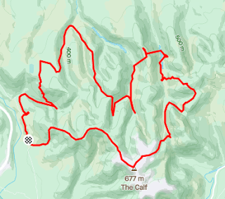
After my 'practice' here I set off for what I really wanted to do on the Howgills. The SLMM was held on the Howgills in 2019 and they had used the map to set up a 6 hour long O after having to cancel the real SLMM this year. I love those hills, despite the really steep valley sides. I chose a good weather day and with good visibility- important where ending up in the wrong valley is easy and a costly mistake. I was early and although two guys turned up as I was leaving it was beautifully quiet. Marking up the map had given me a rough plan of climb, head for the calf and then do a big anti-clockwise loop.

Love these quiet hills

I usually do a linear course so was very unsure if I could complete my plan in 6 hours but there were options to cut it shorter if need be. All was going well and the beeps were working. I think MaprunF is really suited to big areas like this rather than fine navigating as even if the GPS is slightly off it matters less. Also they didn't have to put out or collect in controls over a massive area or risk them going missing while the event was open for weeks. Coming off the Calf I stayed on my nice path slightly too long but soon realised that I needed to drop steeply east to hit the sheepfold. Here was my only disaster of the day. As I reached to trod at the bottom and was about to turn to the control a mountain biker appeared. It was an old boy friend that I have not seen or had any contact with for about 30 years. We were both a bit stunned, chatted but were both under pressure of time. He shot off down the valley and I watched him go before following. I totally forgot that I had not been to the blinkin sheepfold! It was only about 50m away and was worth 80 points. BY the time I realised it would have been daft to go back. The rest of the day was uneventful with some good route choices, sensible nav and reasonable running. I made full use of my allotted time and finished along the fellside road with under a minute to spare! Knackered, hungry, thirsty but happy- despite the 80 missing points. To to it all off some fell runner friends from Preston Harriers were at the cars and I hadn't seen any of them for months. Once home I uploaded my results and was amazed to find I was first lady. I have since been firmly beaten by Karen P but she is a faster runner and also planned the 2019 event on the area.


Our orienteering club set up an autumn series based on Maprun courses. We missed the one in Worden as we were in quarantine after our return from France but although it wouldn't count for points the course was still live so we went and ran it. It gave a reason to navigate and run fast. Here I was very frustrated when I could not get some controls to beep. One was a large boulder and as we have used it before I knew I was in the correct place. I stood on it, walked round it but only got the beep about 5m beyond it. Most others did beep roughly where I expected them to but one on a hedge end refused to. The 'rule' apparently is run to the control point and hope that your GPS trace will show a visit even if you do not get a beep. My trace for the boulder and the hedge end were way off. I was certainly in the right place so I don't know if the problem is tree cover, a poorly georeferenced map, an old phone or speed. If my phone is only set to use GPS every so many seconds then it is possible in park areas to be in and out of a control before it has registered? 

The course in Astley Park was similar. Mostly OK, some beeps before I got to a control and others struggling to beep at all. It was a great course on a very varied area with some tricky and physical terrain by the river, some suburban streets and some very confusing social housing. Fortunately you can review results and set a wider margin for picking it up and so move from mis-punch to OK. I am not entirely comfortable doing that , especially when my trace can be so far off. There was then another different course on Beacon Fell- easy for me even though I left my compass at home.  I did get all the beeps in the end but my trace shows me running through two fenced areas of dense trees rather than on the path next to them- it is impossible to do that and nobody would try. I really enjoyed my run despite the beep issue.


Another great MaprunF  was on Formby sand dunes. It's years since I have orienteered on there and so it would be a good challenge. After a quick warm up I set off full of enthusiasm. First control beep- great. Then I showed just why my orienteering results are so inconsistent. I stormed off in what I was sure was the correct direction but not really using my compass as carefully as I should. I was also running far faster than my brain can navigate. Having briefly run off the map I soon worked out my error and relocated before getting a beep at CP2. It made me a little more careful, particularly as once further into the dunes relocation might not be so easy. Without the few fences areas and the one massive pole/beacon it would be a very much harder area. I had to work hard running on the steep sand but loved it. The day was beautiful with blue sky and little wind, plus most of the people were walking along the beach so it wasn't even very crowded. Thanks to DEE orienteers for letting us run. The course was only 3.5km straight line so even after adding a bit for path running I was soon back. I decided to go out and run a score event on the same control just for fun and then after that did a lap up towards the Red Squirrel area and along the beach. What a fab day and interesting to be back on technical orienteering again.

Cowpe in the sunshine

I have also been across to the moors above Rawtenstall. 


The MaprunFs there used OS 1:25000 maps which was a whole new challenge but I loved my day out running at Clowbridge first (about 7km and under an hour), 

Clowbridge reservoir

the one at Cowpe (about 10km and under 80 minutes) and finally a little one above Marl Pits.  Both allowed me to explore areas I did not know well- I think I last orienteered at Clowbridge at The Harvester in the dark!

Some big climbs and tough terrain

I have been back for a run to link  a load of trig pillars in the area. I also did the Rawtenstall urban - but short, steep and fast is not my forte. 

I did enjoy my first ever Street O Maprunf in Ramsbottam thanks to Matt Driver. A real joy not to have to stop and write with a pencil.

Never spotted this before


Thursday, 5 November 2020

Tier 3 challenge

 Almost no races and in the end the two I did have hopes for were cancelled or I wasn't allowed to travel to them so time for a rethink. Even in Tier 3 we were able to go to climbing walls but I wanted to run too.  An article about the Witches 400 had caught my eye. For the 400th anniversary a new route was established which says it follows the believed route they took from Barrowford to their trial and eventual death in Lancaster. I say "it says" it follows the route as I guess we cannot be sure and in some places I suspect some artistic licence has been used to take todays explorers on quiet paths rather than road or lanes. I had spotted some of the Tercet markers when out running but had thought they were all in Pendle Witch country until a more recent run led me to one above Slaidburn. 

The route looked a bit fiddly for the first 12 miles or so which meant it was a good idea for a reccee run. I am so glad I did as it was easy to miss paths and so waste lots of time faffing with the map or back tracking. It also showed me just how wet and muddy it would be at least until I reached Clitheroe!

After Clitheroe the route is much more straight forward, or so I thought when looking at a map. From Slaidburn it is simple once on the Hornby/Salter fell road. Plus once at the Caton wind turbines it was would also be easy lanes and then the cycle track, so just a short section after the fell road which might be tricky. I hoped I could wing it on the day for these bits. Turns out I couldn't but more of that later.

Trying out my prize OMM cag for the first time

Being a linear route I asked for a lift to the start and a pick up from the finish. To maximise my daylight we opted to stay overnight in the van and so avoid a crazy early start. I was duly dropped in Barrowford as it was getting light. 

A quick walk through the park and I was at the historic visitor centre and the first Tercet. No time to read the poems today though. Steady drizzle so I set off in waterproof trousers too- it was going to be a long day.


Less than 15 mins and the path turns uphill past a ruined farm. This bit is on the Pendle Way and I knew it would be wet and muddy. After the recent rain that was an understatement! Several wet fields, some lane and a pleasant path and I was on the outskirts of Barley. I deviated slightly from the 'official' route here as my reccee showed the path ended in a nasty section of brambles etc. I stuck to the big bridleway instead. In the car park here I removed my over trousers and they stayed off all day. The paths below Pendle were wet but not too bad. Dropping towards Ogden Reservoir I knew to avoid a sort section in an enclosure of trees. The path there is steep and muddy and the bottom is a swamp-  up to my knees.  Second Tercet marker passed.


Over the stream and up into the woods. This path always makes me smile as I remember my son coming to an abrupt halt when orienteering- he was scared there might be bears in the dark forest. No bears today, just a steep climb up to a very very boggy hill before the drop down into Newchurch in Pendle. The official route is blocked by a family claiming to self isolate and wanting nobody on their land. I used the Pendle way instead and was soon at Bull Hole. The path here follows a stream up to Tynedale farm so more wet feet. A short climb onto the next ridge took me past a messy farm and mud churned up from cattle to the Rigg of England (what a great name) before dropping to the edge of Fence village. 

Farm house as old as the Witches

A few fiddly bits near Higham led to better running near the Huntroyd estate and Read. Approaching Whalley I was now on new ground and hoped I would find the paths OK. I was disappointed that the official route didn't actually take me past the Tercet in Spring Wood but never mind.


Somewhere between Wiswell and the A59 I made a small error but I soon picked up paths to lead me back on route and into the Little Moor area of Clitheroe. The 4th Tercet is just inside the entrance path to Clitheroe castle.

Sun now out and I had to remove my cag

Some easy pavement running took me through the town and over the Ribble before I switched to tracks and paths to take me uphill near Waddington. An even bigger uphill followed on the aptly named Moor Lane .. an old track which is now a bridleway. Despite some huge puddles it was fairly runnable. From the top the path heads west towards Newton fell before the big drop to Slaidburn.


 The views from here were great. My descent started well but in my enthusiasm and speed I missed a small footpath turning. It added a bit of time and a couple of km or so as I tried to figure out what had gone wrong and then to find a route to get back on track. I arrived in Slaidburn thirsty. The cafe was quick with a cup of tea but the savoury pie I craved was going to take some time. I opted for cake instead. The piece of cheesecake was enormous and far too rich, I regretted it for several miles. Tercet 5 is in the car park next to the cafe.


Uphill for the next section and some lanes that are now so eroded it won't be long before they are impassable for normal traffic. The official line goes across some fields here but after all the heavy rain I was unsure about a stream crossing as no bridge was marked. I stuck with the lanes, slightly longer and more undulating. As the tarmac ended the old fell track road began, round the edge of Dunsop Fell and Low Fell, over Croasdale Fell and all the way up to the watershed. 

The next Tercet is on the hillside here. I met a few mountain bikers but very few people compared to the crowds down in Slaidburn. In my mind the track after the watershed was all down hill until the next tarmac. It isn't. 


There are no huge hills but when your mind was set on down then any up was bad. I should have stopped in Slaidburn for a more substantial meal. I was carrying plenty but it was all sweet and I didn't fancy it. Also it was a chilly day so I wasn't drinking enough. This was to be my downfall.

The path through Higher Salter farm did not seem obvious so I added a bit doing two small sides of a triangle. Then the path at Mallowdale got a bit rubbish- steep gorge like valley and mud (again) and trees down. It meant I planned an escape to track and lane. Sadly I got so excited when I saw a car heading downhill that I followed at pace, then got chatting at cattle grid gates and before I knew it I was on real tarmac BUT not the right bit. At Roeburndale chapel I should have stopped, eaten and turned round. retracing your steps is never great but what followed was worse, much worse.  In my tired and hungry state my brain decided I could head up over Claughton Moor and so get to Caton Moor and Terect 7. 

Borrowed as I was so stressed at my errors by now

It was now late afternoon so the sun (what there was of it) was west not south and none of the paths or trods headed where I needed to go. Eventually I realised I needed to change compass direction and had a few kilometres of nasty boggy tussocky ground. I reckon I lost about 45 mins all in all. The lane to Caton seemed to go on for ever but I was able to treat myself to a pint of milk in the Spar ( no choc milk available). The cycle way was nicely runnable although my tired legs were not now moving as fast as I would have liked. Tercet 8 is at the Crook of Lune. I was now trying hard to beat 11 hours so no photo stop.

I found the exit and track up past the prison with no issues and emerged on the outskirts of Lancaster as it was getting dark. I bottled the first entrance into Williamson Park as it was unlit and I did not want to stop to find my head torch for such a short section but was braver near the allotments. Not sure why it is only lit from the Ashton memorial and south but I found Terect 9.  too dark for photos so I pinched one.

Now too dark for photos

From here it was all downhill and through town until the final little climb to Lancaster castle and the final Tercet.  

It was dark so a borrowed picture

52 miles done and I just scraped inside 11 hours. I am sure without the errors I can do 10 hours so I will have to have another go! 

Bob had parked the van down on the quayside so my final km or so was also downhill.


Friday, 30 October 2020

Time for a reminisce.

 The summer was awesome. I love being away in our van at ant time but this summer after so much had been cancelled it felt even more special. The weather was fantastic with virtually no rain in over 7 weeks- we had one sight seeing day in slight rain and another where we opted for a short morning bike ride. Almost the whole time was sport rock climbing and driving from crag to crag. Living out of the van meant our only contact with people was food shopping. There were few on the crags, especially when as mad foreigners we climbed in places they won't go in the summer. It was a bit hot- we had to stop climbing at Seynes because the rock got too hot and a few times we got back to the van to find it super heated to 46C.

We revisited some old favourites but also found new places. After no climbing for a few months in the UK the start was a bit of a knock back but we soon got back into it and after a week or so were back to pushing our standard. We are always on the look out for new crags to break the journey and so we tried some north of Dijon. Vertus was OK but very inconsistent with the grades. Cohon was OK and one climb- Green Lizard was lovely. We also discovered Geligny.

Bourmont was awful and I doubt it is ever used now. Vieville had some but wasn't that great. Mont Rome is a lovely hill top but we were shocked to find some routes with no chain at the top and the 'easy' slabs are awful. We got a fair bit done at Fixin and found a new quiet camp spot too. 

Cambolle Musigny was new to us and we liked it as it was not polished. 

Bouilland entertained us for several days with many climbs and a walk. It was very hot but hardly anybody was there.  Idyllic spot for the van- except for the wasps.


We had been to Cormot before but now found easier access for the van and a deserted place to stay so we could sleep with all the windows open.  You don't get views like that on many campsites.


We had now done over 110 climbs and so treated ourselves to a rest with a swim in the lake at Nolay before going back to Cormot for a tough day of 8 hours and all climbs of 25-35m.

Remigny is a favourite of ours although the track is now so trashed and eroded we daren't take the van down to the main parking in case we cannot get back up. We pushed the standard and managed to lead a couple we had failed to do in the past. It left us shattered so time for a change. Off to do some Via ferrata in Lozere. The local council here has set up half a dozen great VF and we were happy to do them again. 


Malzeiu also gave us a river swim (we didn't use a single camp site in over 7 weeks away) and Canargue had a nice cool plateau. 


Liaucous was busier than last time but we got up early and had the VF almost to ourselves. We then moved to Millau and waited for a bit of cool and others to disappear. We were treated to amazing displays of the eagles and vultures soaring all around us.


Many of these new VF have optional zip wires and we were starting to think we should buy a pulley each so we could do them. We should have done it earlier really but my Mende had made the decision and found pulleys at a sensible price. Florac was busier than our last visit as it was still peak season. This is possibly one of my favourite VFs with vultures and such an incredible overhang. There are 4 variations on the exit and none are easy. As we were early we were able to do one, reverse a bit of route and go round to have another go. The toughest is a real test! 

The VF at Villefort was our last in the area and we managed a lake swim before the weather here turned quite a bit cooler and cloudier. As we left there was low cloud and drizzle. No worries we were moving on to Seynes where we had four scorching days.


We kept running out of water and the rock got too hot to hold but we had a great time and the tufa flows were amazing. We must be climbing hard because apparently my fore-arms are almost as big as my biceps!

Another break from climbing took us to Collias. The VF is not graded particularly hard but it is now polished like sheet glass and was perhaps the scariest one we did all holiday. We were glad of the beach and the river to relax by for the rest of the day. It rejuvinated us enough for us to do the VF in Cavaillon- the first half was sweaty and on the second we were racing the sunset. Another long day with tea at 9.45pm!


Gigondas and the Dentelles are beautiful and we like the climbing there. The sun baked side was predictably empty and we managed to lead a few we had not managed before. After two days here we had pushed our total to 202 climbs. We drove to Buis next but the weather changed suddenly so we had a day shopping in Orange and  sight seeing in Vaison la Romain. We had thought about cycling up Ventoux but it stayed in cloud the whole time so we were spared. 


The rain didn't last  and although the next day was chilly it was perfect for the 3 linked VF. 

By the next day on Baume Rouse it was hot and sunny again. Both pushed out standards again. Then we went off to a new to us area Baume Noire. Bit of a dodgy gravel road but all OK in the end and grades were tough here.


A favourite VF is La Caire and they have 3 enormous tyrolienne zip wires so we had to go. Bob still hates the loose wobbly bridge but all in all we had a great time and certainly got value from the pulleys. Compared to renting we have already recouped the cost and we are getting better ta using them. A refreshing swim in the lake before Embrun finished the day off nicely.

The VF at Les Orres isn't hard unless you make it so and only use the rock (photo is a replica of one we have from years ago with Chris stood there) but I wanted to go back and do a massive ridge walk there. 

We had done the middle section with the boys when they were small but not the peaks at either end. It was chilly waiting for the ski lift to open at 9am but we were at the front of the queue and in ten minutes were off into the wilds and alone again. All the serious downhill mountain bikers stayed near the resort. 


We were soon climbing hard and into the sun. The layers came off and we spent most of the day in shorts and T shirts. We also saw only 5 people until we dropped to the lake and started to make our way back to the resort. we took two wrong turns and just as it was all getting a bit fraught I realised how to save the day. If we jogged the next 600m or so we could get to the middle chair lift and hitch a ride down to a beer! Topped of the day perfectly. The views had been amazing all day and it will live in the memories a long time.

Next stop Orpierre and more sun. It was more crowded than other places we had climbed but people kept their distance. 


It was cooler at the start and end of each day plus a fierce wind but we really enjoyed the climbing. By now we felt on fire and spent days doing nothing easier than 5a, mostly 5c, which for us was rewarding. Sadly on the last day on the Quiquillon area a couple of routes had been derigged but we still found 3 really great long routes to challenge us. Autumn was now on the way and we found a new area to climb at Gorges d'Agnielles. The grades were a bit up and down but we had fun and only stopped for lunch at 4pm. It's a tough life...ultra runner does climbing as ultras too.

A river swim on the way to Die gave us a welcome break amongst the bizzare boulders that choke the river. Then I got button-holed by the local fanatic when we stopped for the night at a vulture reintroduction area. He was a nice guy but believed my French to be better than it is. Fortunately I could hardly get a word in edgeways. New treat here too- scrumping for walnuts. We have done the  VF at the top of the pass before but enjoyed it again and then had a walk exploring the surrounding hills in the afternoon. I had spotted a great walk up the highest peak in the Vercors - Le Grand Veymont. It was a long walk in from here but more undulating and less steep than from the east. It was as expected a big day out with some superb views, a few crowds at the summit but otherwise quiet and lots of chamois and bouqutin. We also met some of the dogs that guard the sheep from wolves etc. The ones we met early in the morning were not happy yet late afternoon with a huge flock and their shepherd they were fine.


A day off to travel, shop, get organised and recover meant a lovely drive through the gorges at the heart of the Vercors. Again we opted for the gondola up part way to break the worst of the climb. It was hot and sunny again. The limestone here is amazing and the geology just sucks you in. A lovely little spine of rock was going well until we heard a shout behind us. The old guy we had just overtaken had fallen. He had hit his head and very confused. We got him to lie still and tried not to worry too much about the blood flowing from his ear. His wife was understandably in a state. We were in a pocket of no mobile coverage but luckily 3 trail runners arrived. They were French but also spoke good English. They took charge and one ran off to get signal. After an hour it was agreed there was no point us waiting too. We were relieved but felt a bit guilty- more so when it became obvious they were in for a long wait and we only saw the helicopter appear 3 hours later. I powered up Grand Moucherolle which was quite a scramble and was entertained by eagles soaring. 


The views south along the whole Vercors escarpment were superb. I had run up here years ago when Bob had done a shorter walk and it was good to share it with him. We carried on over Deux Soeurs and came upon a herd of chamois with their young. Then further on a huge herd of Bouquetin that let us get very close. Another long day and we had to drive off or risk being pinned in my the Tour de France that was due to arrive the next evening. We ended up in a car park which seemed vaguely familiar and we both realised it was the old ski jump above Grenoble that we had run up through on the UT4M a few years ago. 

The next day we went to another UT4M area and did some climbing. Again we couldn't stay as we knew Grenoble would be shutting roads for the Tour. It was a hot, stressed and dark drive. We failed to find anywhere suitable to stop and in the end drove all the way up above Chambery to St Jean for a very very late tea and a good nights sleep. 

There are two VF here and although the loop to walk back to do the second one is abit annoying it allowed us a lunch break and both are very worthwhile and tough. We knew we had to start making our way home so the next drive took us to an old favourite-  Vergisson. 


Their wine is expensive but the parking, lavoire, toilets and climbing is great. I love this little village. Today it became even more favourite as I led a 6a. We called in on Vieville to climb on the way back but then it was just a long drive home, the tunnel so we could keep our distance and two weeks of quarantine. Well worth it though - a superb 7+ weeks. We could not possibly have squeezed more in; just how it should be. Live life to the full.